Wildland Firefighting
With the growing frequency and severity of wildfires, monitoring the location and safety of firefighters with reliable satellite coverage has never been more important.
request a demo60K
FIRES
20K
FIREFIGHTERS
10
WEEKS

Intro: In 2024, there were nearly 64k wildfires burning 8.9 million acres in the US, affecting millions of acres of land. More than 20,000 firefighters were mobilized, often to remote and rugged terrain in the western US. Resilient and reliable communication links are a vital component of firefighters’ safety.
Implementation: Geofences are real-time location updates overlaid on a map are valuable but lack the context of what is really happening in the field. Our geofence feature allows firefighters to layer updated fire perimeters onto the map so the entire firefighting team can see the perimeter as they interact with it in real-time.
 EVERYWHERE Hub
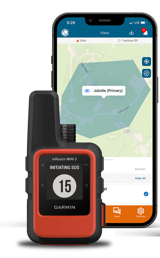
The EVERYWHERE HUB and Mobile App provided real-time tracking and messaging, which allowed the company to locate their personnel, and communicate with them. The app also enabled the company to set up geofencing and alerts, which notified them in case of any boundary breaches (safe or otherwise).
EVERYWHERE Moblie App
Solution: The EVERYWHERE Platform provided near real-time tracking, 2-way communications and Global Team SOS via the Iridium satellite network.
Global Team SOS enables notifications to be sent to the entire firefighting team via automated voice call, text message, or email. When a firefighter pushes the SOS button on the inReach or EVERYWHERE Companion App, the emergency alerts are activated, enabling the proper individuals to act at a moment’s notice. EVERYWHERE has the capability to route Emergency Alerts to any relevant stakeholder through the use of Multi-Channel Notifications, enabling firefighting professionals to determine the best course of action for a rescue in an SOS event.
Results: The use of the inReach Mini 2, along with the ATAK Plugin and cloud-based EVERYWHERE HUB and Mobile App, significantly improved the ability of firefighting teams to coordinate their efforts and respond to wildfires in remote areas.
Learn more about the EVERYWHERE Mobile AppEVERYWHERE Always Connected®
The EVERYWHERE platform is built for seamless interoperability, ensuring that your team has access to the most advanced tools for communication, mapping, intelligence, and situational awareness. Whether responding to crises, managing field teams, or securing remote assets, our integrations help you stay connected, informed, and protected—everywhere.
Ready to enhance your operations? Contact us today to learn more about our integrations and how they can support your mission.