iOS & Android
EVERYWHERE
Mobile App
Messaging, alert notifications, global SOS, advanced mapping with live location information, all within a secure and encrypted app.
See more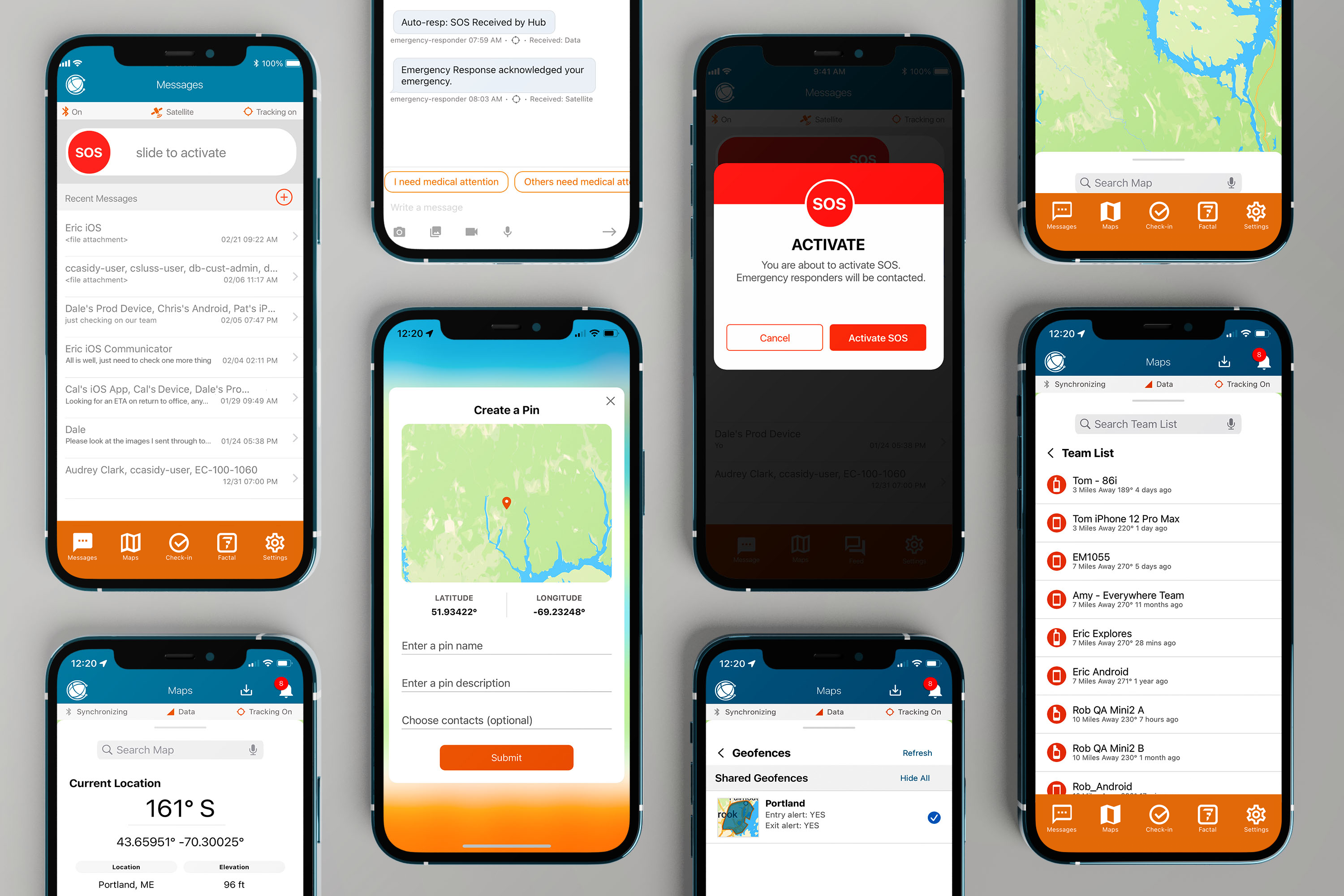

Keeping teams Always Connected
Our iOS and Android App is the tool your teams need to be Always Connected.™ With EVERYWHERE Intelligent Routing™ that seamlessly and automatically switches between cellular, WiFi and satellite (when paired with a Garmin inReach), your teams will never be without vital communications. Features include, messaging, alert notifications, global SOS, advanced mapping with live location information, monitoring of self and team, geotagged photos, videos and audio, geofences, sharable pins, saved map regions, all within a secure and encrypted app.

T-Satellite Connectivity
The EVERYWHERE App is compatible with T-Satellite, allowing field teams to use Android & iOS smartphones to stay connected over satellite when cellular and Wi-Fi are unavailable.
See More Features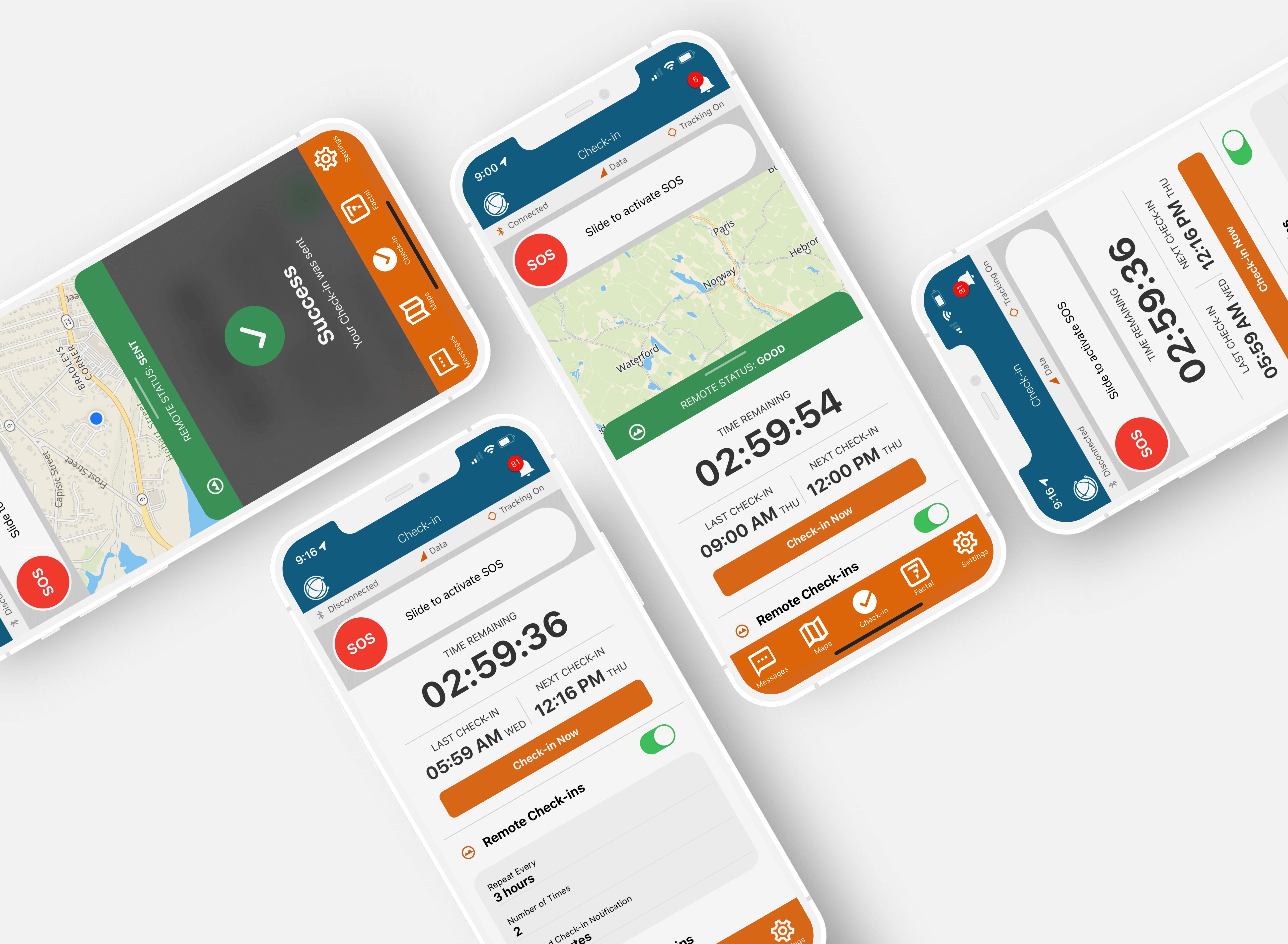

Scheduled and Self Check-ins
We've added a sophisticated yet easy to use check in system to the EVERYWHERE App and Hub. Know that your team is safe in or out of coverage. With a countdown timer and three check-in status bars, app users will always know if they're on time.
Learn more about check-ins

Safety Zone Check-ins
Safety Zones give you smart flexibility and peace of mind. Each Check-in can define one active area—whether it’s a circle, rectangle, or polygon—and within that area, you can add up to ten customizable Safety Zones. These zones, which can also be shaped as circles, rectangles, or polygons, let you create exceptions where no Check-in is required. When a device is inside the active area but within a designated Safety Zone, the system will automatically display “Within Safety Zone, No check in needed”—saving time while maintaining accountability. If a device steps outside active area entirely, Check-ins resume as normal.
Learn more about Safety ZOnes in the Hub

Mass Notifications
With Check-ins integration, Mass Notifications make it easier to stay informed and respond quickly. Organizations can now track acknowledgements in real time across all notification severities, while Critical notifications can override device privacy settings to help ensure urgent emergency alerts are received.
Learn more about Mass Notifications

Garmin Watch Check-in App
Bluetooth pair the EVERYWHERE Mobile App to a Garmin watch to monitor and respond to Scheduled and Self Check-ins
Learn more about garmin watch app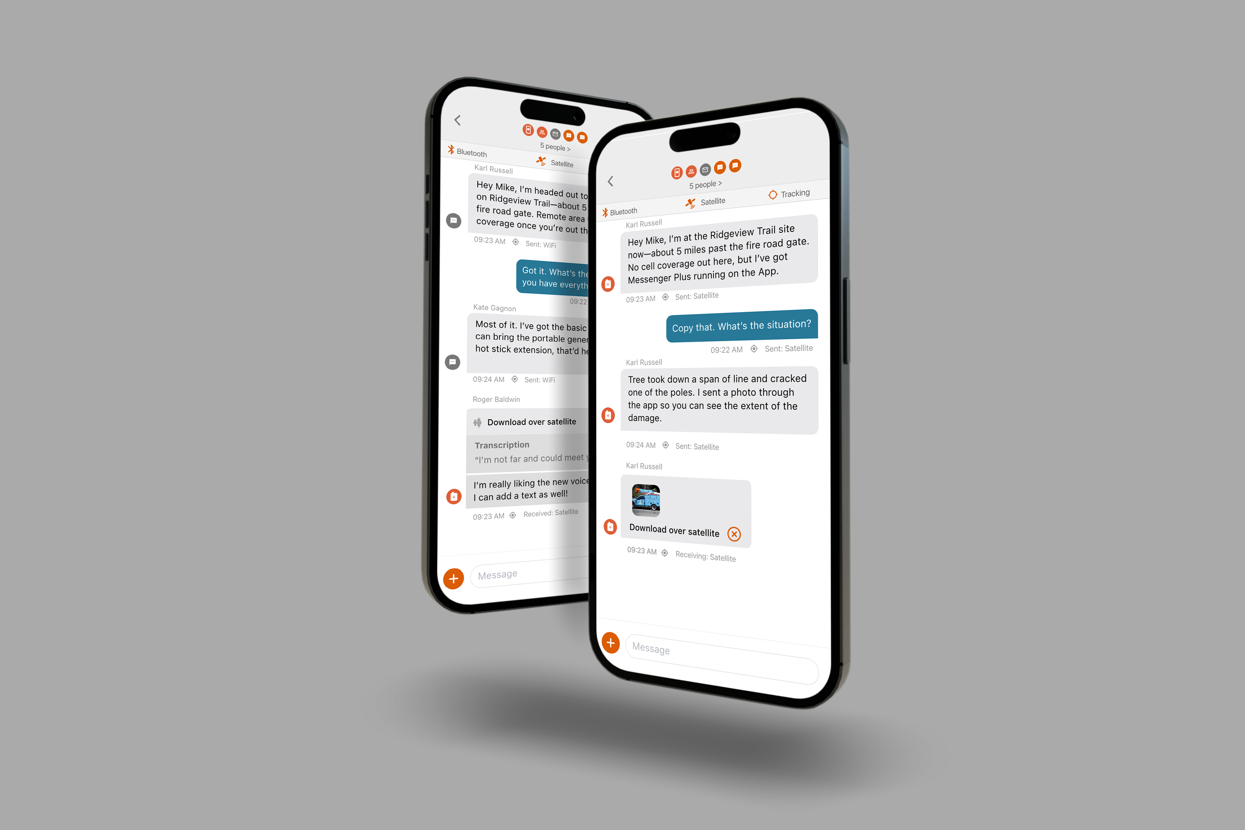

Global Voice Messages and Photos
With global voice messages and photos, you can record and send short audio clips over satellite, Wi-Fi, or cellular networks using the EVERYWHERE Mobile App and the Garmin inReach Messenger Plus. Each received voice message is accompanied by an automatic text transcription, so recipients can read or listen based on their environment or preference. Thumbnail photos are sent initially over satellite with the option to download higher res images over satellite or later over cell or Wi-Fi.
Learn more about inReach Messenger Plus

Files
A Mission Vault with a dedicated Files tab in the mobile app's navigation, allows users to view and download essential files seamlessly. Quickly share local in-country risk information such as emergency contacts, local hospitals, or safe routes w/ your field teams. Enhance the onboarding process by sharing tutorials to be downloaded while off the grid.


Scheduled Monitoring
App users can manually turn monitoring on or off at any time. This gives them the flexibility to use the app as they see fit, while still enjoying the added security of knowing they are being monitored during the scheduled times.
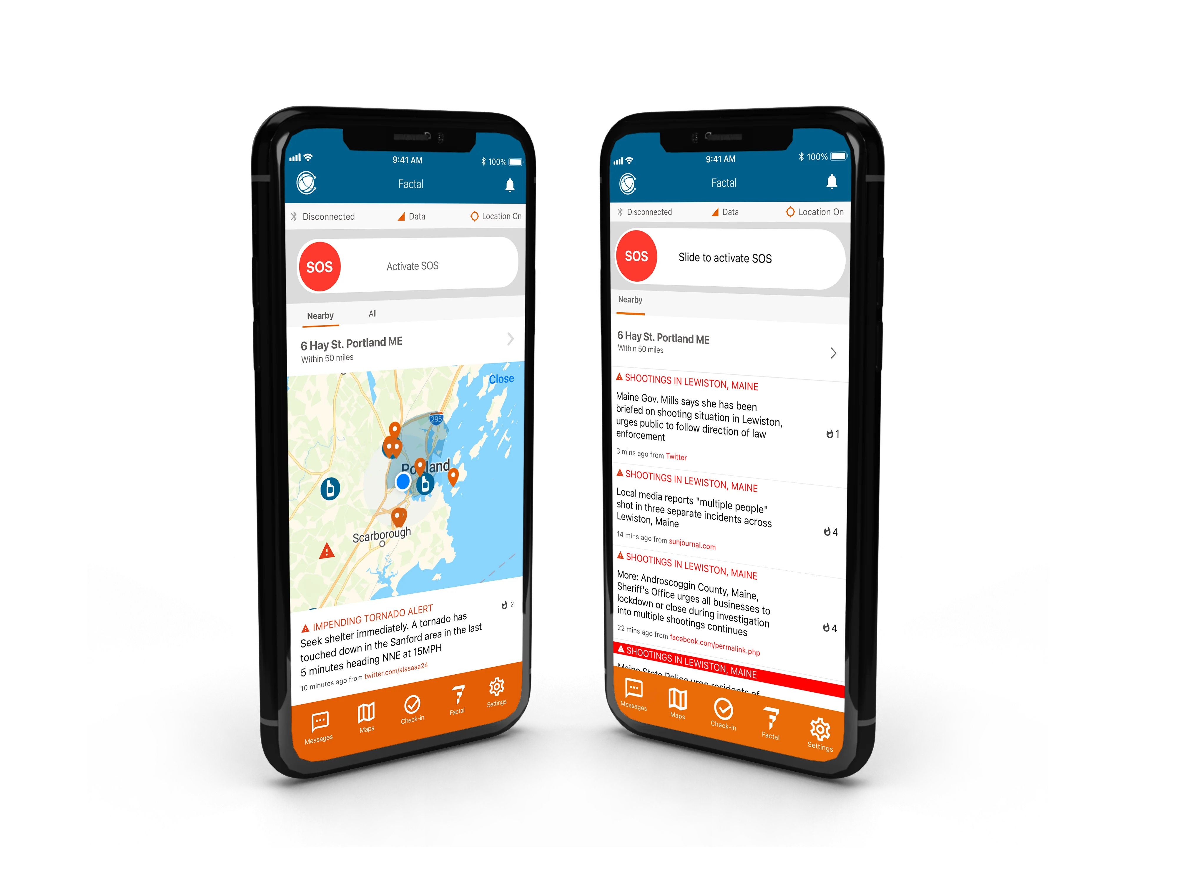

Geolocated Risk Intelligence powered by Factal data
Discover emerging and high-risk events ahead of major media reports with geolocation of you and your teams. Powered by a hybrid of AI and experienced journalists, Factal detects early signals, filters out the noise and verifies the facts at the speed of social media. Allows your teams to see each other on the map in proximity to events to gain a clear operational picture and impact.
Learn more about factal integration

Map Drawer
Open the menu of mapping applications by dragging up from the bottom of the screen to see current location (latitude/longitude), select map type (street, satellite, topo) and manage both team visibility and layers.


Pins
Points of interest with coordinates can be dropped on the map, edited and shared with teammates out in the field.
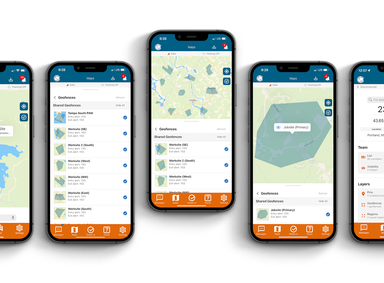

Geofences
Virtual boundaries can be added to the map to indicate high-risk areas or reference location.

Interoperable Communications
Device icons distinguish users and groups in messages, with orange icons for users within the EVERYWHERE Platform and gray for external users to make multi-network messages simple and easy to understand. Stay private and secure knowing all of your team’s communications are AES 256 secure and encrypted. Attach audio clips, photos, or videos with time stamps, location and data pathway information on every message.

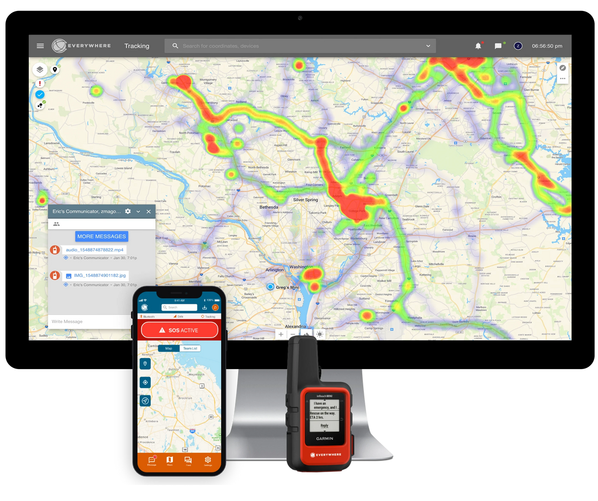
EVERYWHERE Intelligent Routing™
Two way messaging and seamless data file transfer via most efficient network based on preferences and availability of Wi-Fi, Data, or Iridium satellite when paired with a Garmin inReach.


Global Incident Command System
Activate an SOS in an emergency to communicate with 24/7 emergency personnel and with teammates.
Learn more about EVERYWHERE SOS

Geotagged Photos
Users can share geotagged photos, video and audio with both the app and Hub. Document job sites, arrange pick-up or drop-off locations, all within our Always Connected platform.
FAQ

FirstNet
EVERYWHERE App is now available on FirstNetThe FirstNet mission is to deploy, operate, maintain, and improve the first high-speed, nationwide wireless broadband network dedicated to public safety. This reliable, highly secure, interoperable, and innovative public safety communications platform will bring 21st century tools to public safety agencies and first responders, allowing them to get more information quickly and helping them to make faster and better decisions.
More about integrations